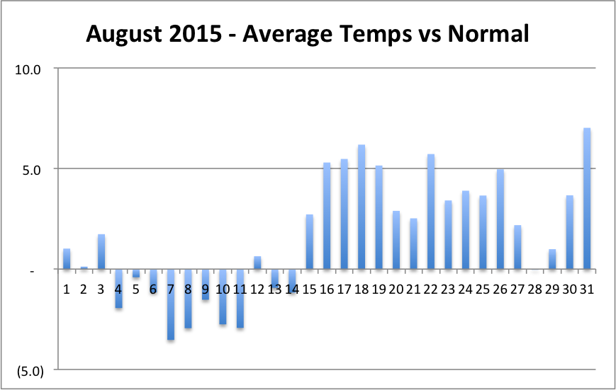
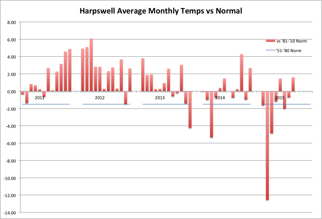
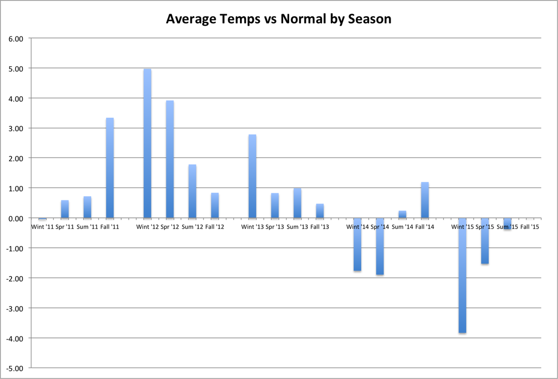
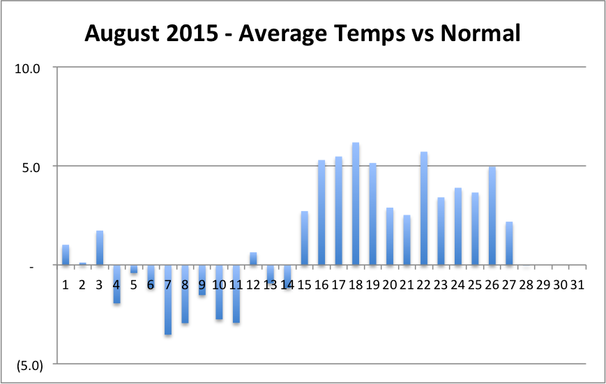
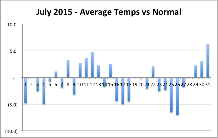
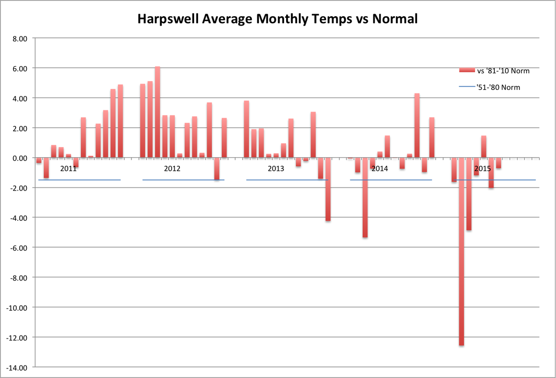
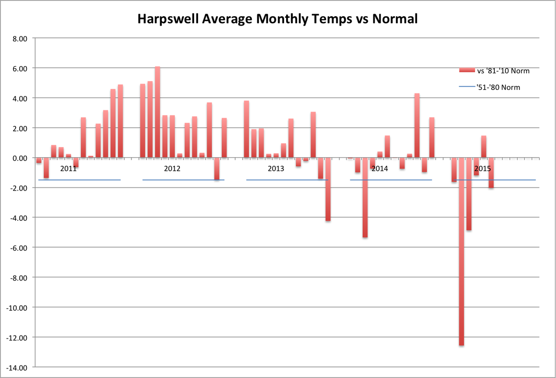
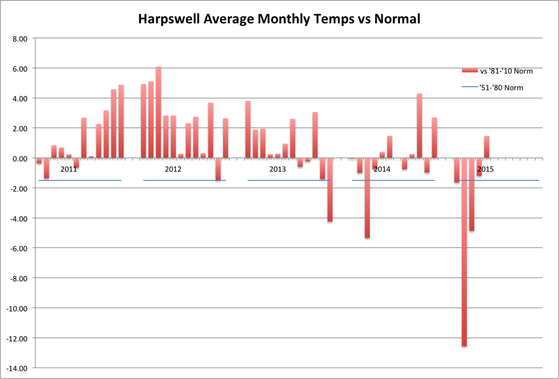
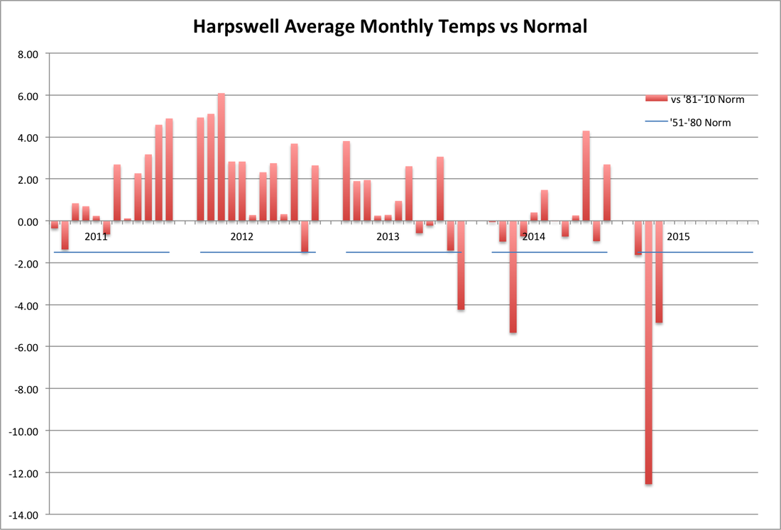
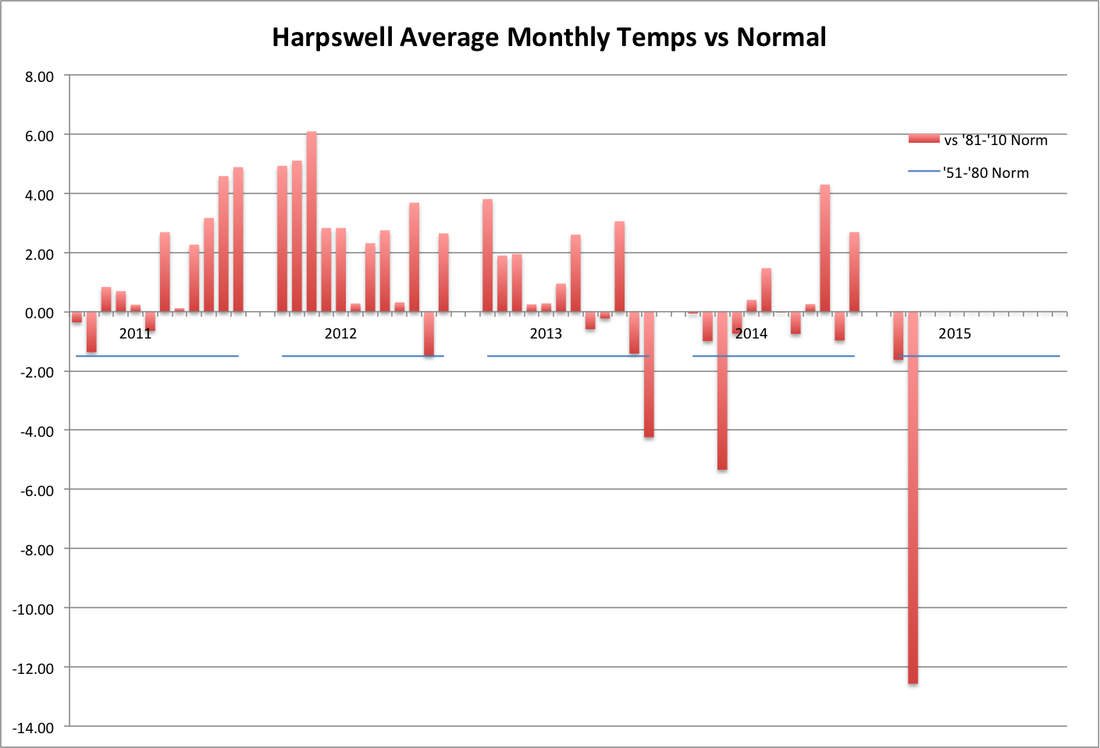
Just when summer started to slip away, on August 15th (the first time the normal daily temperature dropped since January 3rd), we started an extended period of warmer than normal temperatures. On the 28th, temps were ever so slightly below normal, but other than that the warmer than normal period continued until September 3rd, which would have been 20 consecutive days above normal, tied for the longest streak I have seen on my weather station (since January 2011). August average temperatures were warmer then July, which only happens about one year in three. That they were warmer by 1.9 degrees is very unusual; August has only been that much warmer than July 8 times in the last 74 years in Portland. But it wasn't enough to keep this summer from being the 3rd consecutive season colder than normal (see fourth graph), based on meteorological seasons (summer = June, July and August), the first time that has happened at my station.
0 Comments
Thirteen consecutive days warmer than normal came to an end yesterday by .003 degrees! (If you look very closely at the graph there is the thinnest of slivers of blue below the line for the 28th.) And the 10-day forecast indicates it might be a while before we have another cooler than normal day. Oh well, the end of a streak like we hadn't seen since 2013, and the first time this year we have had more than a week of warmer than normal weather.
It has now been over two years since temperatures exceeded 90 in Harpswell - just the way we like it. July continued the below normal temps of 2015, though not by much especially after a warm end to the month.
Although we hit 80 on six different days, many cool days and nights kept the average for the month about 2 degrees below normal. Two days were more than 10 degrees below normal; we had never had even one day that far below normal in any month from May through October in the 54 months I have been keeping track in Harpswell.
May was our first warmer than normal month this year in Harpswell, but many days of cool sea breezes kept it from being the much warmer than normal month that Portland had. May was 4.6 degrees cooler in Harpswell than Portland, a much larger differential than I've seen in any month. Previously, the largest differential in a single day was 7.6 degrees; in May we doubled that record on the 26th, which was 15.2 degrees cooler in Harpswell than Portland, and had four days with a differential of more than 10 degrees.
The cold weather continued for the first 10 days of the month, including 6 days more than 5 degrees below normal, but then the weather pattern finally changed and the last 20 days averaged slightly above normal. We only had one more day after the 10th that was more than 5 degrees below normal. But for April as a whole, it was still the 4th consecutive month at least a degree colder than normal in Harpswell. We finally hit 60 degrees on the 14th, for the first time this year, and that started a stretch of 7 days out of 9 with a high temp over 60. A welcome change!
Harpswell temperatures were about 1.7 degrees below Portland for the month, the 5th time in the last 7 months we have had a negative Harpswell differential, after that happened only once in the months of September-April in the prior 3 years. It is normally cooler in Harpswell than Portland from May-August, but not previously in the other 8 months. After getting to 99 1/2" of snow for the winter on March 4th, and having had snow on 20 of the previous 40 days at that point, we had to wait until the 15th for another 1/4" and we finally made it to 100" on the 21st. Another milestone! I was beginning to worry we wouldn't make it. The much colder than normal weather continued, as we had another 8 days more than 10 degrees below normal, and still none 10 degrees above normal since January 19th. For the month as a whole, March was almost 5 degrees below normal in Harpswell, the 3rd coldest month relative to normal, in the last 51. On the warm side, we finally made it over 50 degrees on the 11th.
In Portland, where they have been keeping track since 1941, this was the coldest February ever (average temperature 13.8). In fact, there was only one month that was colder (January 1971 at 12.2). In Harpswell, temperatures were 12.6 degrees below normal, which looks a bit out of place on the first graph below, more than twice as far from normal as any other month in the last 50. There was only one day warmer than normal in February. There were 19 days more than 10 degrees below normal and 10 days when the low temperature was below zero, including a minus 12.3 on the 24th, the coldest temperature ever recorded at my weather station.
And we've had some snow. We finally went more than two consecutive days without snow for the first time since January 17-23, as it has been dry since February 26th. In between, we had 74.5", over 6 feet of snow, in 33 days! In Harpswell, we had more than 40" in both January and February. In Portland, NOAA has been keeping track of snowfall since 1881 and they have never had consecutive months with more than 40" (not even this year, since they only recorded 34" in Portland in February). Springtime? We'll be ready. Yes, we finally had a warmer than normal day in Harpswell yesterday. Not by much though and it still looks like this will be the last warm day this month. After reaching 40 yesterday afternoon for the first time since January 22nd, temps dropped fast during the evening and made it closer to normal than the forecast predicted.
Ok, I'll admit, the title was just to try to attract readers, but the weather sure has been on a cold and snowy streak here in Maine! The first graph shows we have yet to have an above normal day, temperature-wise, so far this month. That streak started on the 31st of January and will continue through today, the 21st, for a total of 23 consecutive days. In the previous 50 months that I have been keeping track, we never had more than 12 consecutive days colder than normal. If the forecast holds, tomorrow will end that streak by being a few degrees above normal. After that, the forecast is for more much-colder-than-normal temps for the remainder of the month. We'll see.
Through today, we will have had 14 out of 21 days in February that were at least 10 degrees colder than normal. The forecast says we will have at least a few more of those. Previously in my records, we had never had more than 9 days in a month that were 10 or more degrees colder than normal (March 2014). So far, February has averaged 12.5 degrees below normal. None of the last 50 months have been more than 5.3 degrees below normal (again, March 2014). That will be way off the scale of my latest graph (through January) of monthly temperatures vs normal. Yes, it has been cold. How cold? Well, the second graph shows that the 19th was the first day this month when the low temperature (the blue diamond) was above 10 degrees. Another streak gone. In Portland, where NOAA has been keeping track of temperatures since 1941, it looks like this will be the coldest February ever recorded. The record low February is an average temperature of 15.6 in 1979. Through the 20th, Portland is averaging 12.9 and average temps are unlikely to change that much through the 28th based on the current forecast. We have also had a long streak of snowy weather. Since January 24th, we have not gone more than two consecutive days without snow. As I write this, it is still snowing, but we have at least 3" today. That brings our total since January 24th to 67" in 28 days. This streak also appears to be about to end. The 7-day forecast is for no snow after tonight. Wow! Amazing weather. |
SOURCEWeather statistics are based on 5-minute readings at an Ambient Weather station near Mill Cove off of upper Harpswell Sound. Archives
December 2015
Categories |